Popular Posts
-
 Lahaul and Spiti : Himachal Pradesh Lahaul and Spiti is a district of Himachal pradesh in India. Lahaul tends to be a bit more ...
 -
 Valley of Flowers National Park Valley of Flowers National Park is an Indian national park , located at a h...
 -
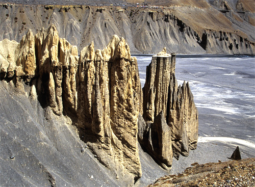
 It is like a desert in the midst of snow-capped mountains. This place has very scenic, natural landscapes. View from the top before rea...
 -
 Gurez or Gurais , also pronounced Gorai in the local Shina language , is a valley located in the high Himalay...
 -
i faced it during my trip in Corbet.. i had this regular water and got food poisoning.. since that day i prefer packaged drinking water ins...
-
Till the time you are travelling or in a way to your destination prefer light, less oily and less spicy food.. And always keep some fruits, ...
-
When preparing to travel, lay out all your clothes and all your money. Then take half the clothes and twice the money.
-
from the today's date.. i proudly call my self a solo Bag packer traveler.. i will keep you update with all the tips and experiences i g...
Tuesday, 18 March 2014
Prefer light food during journey..
Till the time you are travelling or in a way to your destination prefer light, less oily and less spicy food.. And always keep some fruits, chocolates, a packet of buiscuits and a watter bottle in your bag.. And also keep a pack of toilet paper and soap strips/ sanitizer.. Keep these tips in mind and enjoy your trip.. Have funnn.... :)
Wednesday, 25 September 2013
Gurez: Crown Jewel in Paradise


Gurez or Gurais, also pronounced Gorai in the local Shina language, is a valley located in the high Himalayas, about 86 kilometres (53 mi) from Bandipore and 123 kilometres (76 mi) from Srinagar in northern Jammu and Kashmir, India. At about 8,000 feet (2,400 m) above sea level, the valley is surrounded by snow capped mountains. It has diverse fauna and wildlife including the Himalayan brown bear and the snow leopard. The Kishanganga River flows through the valley. The road to Gilgit runs through Gurais.Gurez is a place for solo travellers, as the drive from Bandipura to Gurez is not comfortable. Just for information, Gurez is 80 km from Bandipura, a 4-4.5 hour drive. The Razdan pass is thrown open in May/June and the road is closed for traffic by mid November. There are no specific attractions in the Gurez valley, but the experience of being there and serene environs is worth the stay at Gurez.
The Gurez Valley is a fertile, fifty-mile cleft carved through the Himalayas by the mighty Kishenganga River. It sits directly below the high-altitude Line of Control that divides Indian and Pakistani sectors of Kashmir and is one of the most tensely guarded frontiers in the world. Thanks to its topography, Gurez, which is on the Indian side, has long been a popular gateway for Pakistani militants attempting to sneak into Indian territory. Hence, for security purposes, Gurez had been closed off to the outside world by the Indian army from 1947 until August, 2007, when it was deemed safe enough to open it up to visitors. These are the first images taken by a Western photographer to emerge from the area in over sixty years.
The people who live in Gurez belong to the Dard Shin tribe. Apart from the main town of Dawar, most of the crooked wooden villages that dot the floodplain have no electricity, plumbing, or telephone. For half the year, the tribespeople are completely sealed off from the rest of the world, as the one road in and out of the valley is buried deep beneath snow. In the highlands surrounding Gurez, nomadic Gujjar shepherds arrive every summer from other parts of Kashmir, and from Punjab, to graze their goats.
This is a deeply isolated place that's beautiful and weird, idyllic and surreal, at once an alpine Shanrgi-La and a militarized zone: dazzling fields of wildflowers are cut by coils of razor wire that unroll to the horizon; shepherds climb one slope as soldiers patrol another. The 19th century British historian, Sir Walter Lawrence, who investigated this old tributary of the Silk Road, called Gurez a "valley of unexplored treasures" framed by mountains of "indescribable grandeur." It still is, said by " Michael Benanav"
Tuesday, 26 March 2013
Lahaul and Spiti district.. the most unexplored destination..
Lahaul and Spiti: Himachal Pradesh
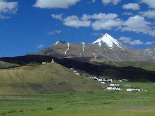

Lahaul and Spiti is a district of Himachal pradesh in India. Lahaul tends to be a bit more green and fertile, while Spiti is mostly stark high-desert.
Most sparingly populated region, Lahaul and Spiti in Himachal Pradesh is located in the southern side of Ladakh. The surrounding snowline, climate, sky-touching mountain ranges, Buddhist monasteries and outstanding scenic beauty have made this place calm and truly grandiose
.
Cities
Kaza – the regional headquarters of Spiti district.
Keylong – the regional headquarters of Lahaul district.
Other destinations
Kibber – a small village at alt. of 4200 m, starting point of the Tso Moriri trek
Ki – the Ki Monastery
Pin Valley – Beautiful valley best place to get a glimpse at rare snow leopard in winter
Chandra Taal – Origin of Chandra river , a big and beautiful lake 7 km away from kunzum pass ideal place for camping in summer
Tabo – a charming little village set around a monastery
Route to Reach
The common way to travel to Lahual is through ‘Rohtang La’ mountain Pass from Manali and to visit Spiti valley, you have to go from Lahual via ‘Kunzum Pass’, a 4551 metres elevated mountain Pass.To enjoy the unspoiled beauty of Spiti, entry from Manali via Rohtang and Kunzum La is ideal, the high altitude desert landscape with virtually no civilisation till Kaza is a sight to behold. There is bus service from Manali to Kaza, subject to weather conditions (open passes), please check with Himachal Roadways at Manali. After passing Rohtang pass (two hour drive from Manali) one away from civilization till next stop at Kaza, eight to ten hours away, Highest point on the road is snow covered Kanzum pass (14931 ft), nearly five hours from Rohtang pass, provide breathtaking view of Shigri Glacier. Just before Kaza signs of civilisation reappear. On the way just before the climb of Kanzum La (La means mountain pass) starts at Batal, the road bifurcate for Chandra Tal (approx 10 km/2-3 hours), where basic camping facilities are available and time permitting, deserves a visit especially during full moon. it is advisable to hire a SUV from Manali. Nearly all tour operator provide service, prices fluctuate so do bargain and ask for a deal with accommodation Kaza and other places you intend to visit in valley. Insist on a experienced local driver from valley, as they understand the weather and topography, also ensure that SUV is in good condition.
The alternative entry is from Shimla (Capital of Himachal Pradesh) side from Kinnaur valley which more comfortable all weather road till Kaza, the route is longer and captivating but landscape is typical Himalayan, unlike the route from Manali. If taking Shimla route plan for overnight stay along the way preferably at Reckong Peo. Please not that you do need an inner line permit to travel on part of this road.
Accommodation beyond Manali and Shimla is very basic although Kaza does offer some better options with opening of few new Hotels but don’t have high expectations.
Caution
Sea-buckthorn also called Leh Berry grows in wild, ask locals before eating. At high altitude fresh water from snow is refreshing, but don’t drink before consulting local residence.
Bus drivers can be far less careful than you would like, especially on windy mountain roads. But government buses seldom meets accident as they have experience on those roads, private buses may be at risk.
Take care when heading out trekking, it's easy to get lured into thinking you're out for an easy stroll, but make sure you've got enough food and water for the whole trip and then some. Be sure not to wander on unknown tracks, u may get lost in cold desert, make sure someone know where you are going.
Images


Tuesday, 12 March 2013
Nubra Valley, an amazing valley...

It is like a desert in the midst of snow-capped mountains. This place has very scenic, natural landscapes. View from the top before reaching the valley is just out of the world. I felt humbled at the size of the mountains and the depth of valleys.
There is a small desert with a small creek in the Nubra valley where camel rides are available. A few temples nearby are also good. Must visit are the hot natural hot springs nearby. A truly enriching experience. You require at least one full day to cover all the places and spend reasonable time at each place calmly.
Like the rest of the Tibetan Plateau, Nubra is a high altitude cold desert with rare precipitation and scant vegetation except along river beds. The villages are irrigated and fertile, producing wheat, barley, peas, mustard and a variety of fruits and nuts, including blood apples, walnuts, apricots and even a few almond trees. Most of the Nubra Valley is inhabited by Nubra dialect or Nubra Skat speakers. The majority are Buddhists. In the western or lowest altitude end of Nubra Valley near the Line of Control i.e. the Indo-Pak border, along the Shyok River, the inhabitants areBalti of Gilgit-Baltistan, who speak Balti, and are Shia and Sufia Nurbakhshia Muslims
Siachen Glacier lies to the north of the valley. The Sasser Pass and the famous Karakoram Pass lie to the northwest of the valley and connect Nubra with Uyghur (Mandarin : Xinjiang). Previously there was much trade passing through the area with western China's Xinjiang and Central Asia.
Special Attraction: Bactrian camels, Seabuckthorn berries, unexplored landscape, hot springs, Sand Dunes, Diskit monastery, Green dense Forest, Rivers and crystal clear Lakes
Road: you can hire Bike, tourist cab, or bus to reach Nubra Valley, from Leh-Khardungla pass(the highest motor able road in India) - Nubra valley..
NOTE:one has to seek permission from tourism department to reach here as its at border area. taking permission is not a big deal one can easily get it by filling a form..
Season / Months to visit : April-September
Season / Months to visit : April-September


Saturday, 2 March 2013
Valley of Flowers (Uttarakhand)

Valley of Flowers National Park
Valley of Flowers National Park is an Indian national park, located at a height in West Himalaya. The valley is enriched with thousands of different species of flowers, flora and also home to rare and endangered animals, including the Asiatic Black Bear, Snow Leopard, Brown Bear and blue sheep. The Valley zone lies between the mountain ranges of the zanskar and Great Himalayas.
State: Uttarakhand, India
District: chamoli
Nearest town: Joshimath
Location: The Valley of Flowers is nestled in the upper expanses of Bhyundar Ganga near Joshimath in Gharwal region.
The Valley is 20 km northwest of Nanda Devi National Park across the wide valley of the Bhyundar Ganga. It is one of two hanging valleys lying at the head of the Bhyundar valley, the other being the shorter Hemkund valley which runs parallel some 10 km south. It runs east-west approximately 15 km by an average of 6 km wide, in the basin of the Pushpawati river, a small tributary flowing from the Tipra glacier which descends from Gauri Parbat in the east.
Road Route from Delhi: Delhi – Meerut – Haridwar – Rishikesh – Rudraprayag – Joshimath – GovindGhat – Trekking (17 kms) – Valley of Flowers..
By Air: Jolly Grant Airport is the nearest Airport to Valley of Flowers but the roads are only connected upto Govind Ghat from where you have to commence trek of 16kms to reach Valley of Flowers.
By Rail: The nearest railway station to Valley of flowers is Rishikesh but the roads are only connected upto Govind Ghat from where you have to commence trek of 16 kms to reach Valley of Flowers
Best time to visit : From mid April to June temperatures are moderate to cool (19°C maximum). . The Valley of Flowers also has the microclimate of an enclosed inner Himalayan valley, and is shielded from the full impact of the southwest summer monsoon by the Greater Himalaya range to its south. There is often dense fog and rain especially during the late summer monsoon. Both Basin and Valley are usually snow-bound for six to seven months between late October and late March, the snow accumulating deeper and at lower altitudes on the shadowed southern than on the northern side of the valleys..


Tuesday, 27 March 2012
A short n simple tip for a traveller..
When preparing to travel, lay out all your clothes and all your money. Then take half the clothes and twice the money.
Monday, 5 March 2012
Always prefer packaged water instead of regular water
i faced it during my trip in Corbet.. i had this regular water and got food poisoning.. since that day i prefer packaged drinking water instead of regular water.. as u take water in large quantity comparative to food and its in liquid form thus it is more susceptible to food poisoning..
Subscribe to:
Comments (Atom)